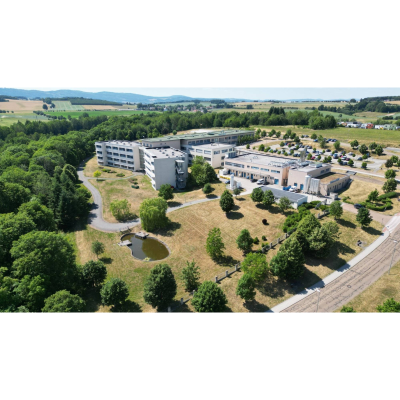
Building Passportization – Domažlice Hospital
Client
Domažlická nemocnice, a.s.
Year
2023
Locality
Domažlice, Czech Republic
The building passportization of Domažlice Hospital was carried out to create accurate as-built documentation of the hospital complex. The project provides reliable data for efficient facility management, future renovations, and long-term asset administration. The scope included surveying both interior and exterior spaces while ensuring minimal disruption to the daily operation of the hospital.
To capture complete spatial information, a combination of mobile laser scanning, GNSS surveying, and digital data processing was used. Integrating multiple surveying methods made it possible to create a comprehensive representation of the existing conditions across the entire hospital site.
The collected data were processed into detailed digital documentation that serves as a reliable foundation for design work, facility management, maintenance planning, and future development of the hospital campus.
Project Challenges
The survey was carried out during the hospital's normal operation, requiring careful coordination to minimize disruption to patients, medical staff, and everyday healthcare services. Another key challenge was integrating data collected from multiple surveying methods into a single, consistent digital dataset suitable for long-term building management.
Project Deliverables
- Complete building passport documentation
- As-built documentation of the hospital complex
- Digital documentation for facility management
- Survey data for future renovation and design projects
- Accurate spatial documentation of existing conditions
- Digital assets supporting long-term building management
Project timeline
Project preparation and coordination
Definition of the project scope and coordination of surveying activities to accommodate the continuous operation of the hospital.
Building survey
Comprehensive surveying of interior and exterior areas using mobile laser scanning and GNSS surveying technologies.
Processing the captured data
Processing and verification of collected survey data, including the creation of point cloud datasets and digital project files.
Producing the documentation
Preparation of detailed as-built documentation to support facility management, maintenance planning, and future design activities.
Review and handover
Final quality review and delivery of the complete documentation package to the client.
Technologies used
Mobile laser scanning
Fast and accurate surveying of hospital interiors with minimal impact on everyday operations.
GNSS geodetic surveying
High-precision positioning and georeferencing of the hospital complex within a unified coordinate system.
Digital data processing
Processing point cloud data into structured as-built documentation suitable for design, facility management, and long-term asset maintenance.
We use cookies to give you the best experience on our website. Necessary cookies are always active, analytics and marketing cookies are only used with your consent. More information is available on our Cookies page.